Polder map of the lands between Maas and IJ by W.H. Hoekwater, 1901
Water system and urban form in Holland

A survey in maps: 1575, 1680, 1900 and 2015

Authors

  • Jaap Evert Abrahamse
  • Menne Kosian
  • Reinout Rutte
  • Otto Diesfeldt
  • Iskandar Pané
  • Yvonne van Mil
  • Thomas van den Brink
  • Arnoud de Waaijer

Abstract

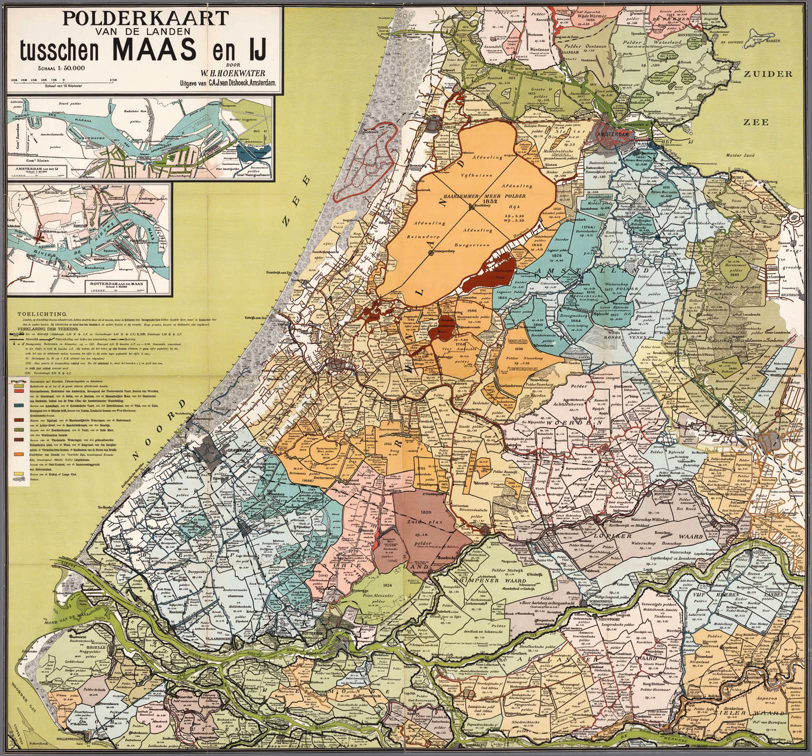
In 1901, the Polderkaart van de landen tusschen Maas en IJ (Polder map of the lands between Maas and IJ) appeared in print. This large coloured wall map was the work of W.H.Hoekwater of Charlois, a teacher by profession.The map had an educational purpose: Hoekwater wanted to show just what a ‘singular country’ this low-lying area of the Netherlands was, built and maintained through the ‘sheer willpower and genius of earlier and current inhabitants’. His explanatory notes consist of a brief technical introduction and, most notably, a summary and description of the storage drainage systems and associated hydraulic engineering works, with tables showing the different water levels. Hoekwater had two versions of his explanatory notes printed, one for municipal, polder and water boardadministrators and one for school children.
Hoekwater’s map showed the hydraulic engineering works in the area between the rivers Maas and IJ, and how those entities discharged into the waters outside the dyke system. Hoekwater had drawn the map on his own initiative, without having been commissioned to do so by a district water board or any other organisation. Since the sixteenth century, large wall maps of various water board districts had been made at the behest of dyke and polder boards. Those older maps show the territory of the relevant water board complete with watercourses and the main ngineering works under its control. None of those maps transcends the level of scale of a single water board district. But it is not just its scale that makes Hoekwater’s unique. Hoekwater depicts the entire water system and its operation in an innovative way, using colour schemes to enable viewers to follow the flow of water.


Erratum

Rowin van Lanen is erroneously not listed as author of 'Water system and city form in Holland'.

Note 1 on page 47 should read: This research was a collaboration between the Cultural Heritage Agency and the Faculty of Architecture at Delft University of Technology. The texts were written by Jaap Evert Abrahamse, Menne Kosian and Reinout Rutte; they serve as explanatory notes to the maps, which were compiled by Otto Diesfeldt and Iskandar Pané on the basis of a historical GIS created by Menne Kosian and Rowin van Lanen, and expanded under the supervision of Yvonne van Mil by Thomas van den Brink and Arnoud de Waaier. The writing of this text would not have been possible without the cooperation of Guus J. Borger, who provided critical comments on an earlier version, of which grateful use was made.

How to Cite

Abrahamse, J. E. ., Kosian, M., Rutte, R., Diesfeldt, O., Pané, I., van Mil, Y. ., van den Brink, T. ., & de Waaijer, A. . (2021). Water system and urban form in Holland : A survey in maps: 1575, 1680, 1900 and 2015. OverHolland, 13(21), 47–121. Retrieved from https://overholland.ac/index.php/overholland/article/view/227

Published

2021-06-30

Issue

Section

Articles

Author Biographies

Jaap Evert Abrahamse

Jaap Evert Abrahamse (1967) studied history of architecture and urban planning at the University of Groningen. In 2010 he obtained his PhD with honours at the University of Amsterdam for a dissertation entitled De grote uitleg van Amsterdam: stadsontwikkeling in de zeventiende eeuw (Metropolis in the Making. A Planning History of Amsterdam in the Dutch Golden Age). He is a senior researcher in historical urban planning at the Dutch Cultural Heritage Agency of the Netherlands, where, among other things, he worked on the Atlas of the Dutch Urban Landscape.

Menne Kosian

Menne Kosian (1964) studied Mediterranean archaeology, classical history and logic at Amsterdam’s Vrije Universiteit. In 1996 he joined the Dutch Agency for Archeological Research (now Dutch Cultural Heritage Agency of the Netherlands) and worked as archaeological draftsman/cartographer. He now holds the position of researcher spatial analysis in the landscape department where he works on the development of GIS for historical landscape research and historical cartography. His research is currently focused on historical (underwater) landscapes and water management systems, based on the development and application of historical archival and cartographic data.

Reinout Rutte

Reinout Rutte (1972) is an urban and architectural historian. Since 2004 he has been an assistant professor in the Chair History of Architecture and Urban Planning in Delft University of Technology’s Faculty of Architecture. Together with Jaap Evert Abrahamse, he published the Atlas of the Dutch Urban Landscape (2016), and together with Bram Vannieuwenhuyze the Stedenatlas Jacob van Deventer (2018).

Otto Diesfeldt

Otto Diesfeldt (1976) graduated with an honourable mention in architecture at Delft University of Technology in 2003. He worked successively for De Nijl Architecten and Dick van Gameren Architecten; since 2013 he has been employed by Mecanoo Architecten. He is also a part-time researcher in Delft University of Technology’s Faculty of Architecture. His research work focuses on cartographical reconstructions of transformation processes in Holland’s towns and cities. Together with Iskandar Pan  he is responsible for the cartographical studies in Over- Holland.

Iskandar Pané

Iskandar Pané (1974) studied architecture at Delft University of Technology. After graduating he worked for De Nijl Architecten and KAW architecten in Rotterdam. He now works at CBRE, an international property and housing advisor. He is also a part-time researcher in Delft University of Technology’s Faculty of Architecture. His research focuses on cartographical reconstructions of transformation processes in the towns and cities of Holland. Together with Otto Diesfeldt he is responsible for the cartographical studies in OverHolland.

Yvonne van Mil

Yvonne van Mil (1979) studied architecture at Delft University of Technology, where she specialized in public space in port cities. Since 2010 she has worked as a freelance researcher and cartographer and is affiliated with Delft University of Technology’s Faculty of Architecture. Her research work focuses on spatial transformation processes and cartographic reconstructions, with a focus on regional development. She has coauthored several books, including the Atlas van het Westland (2016) and Driven by Steel (2016). She also collaborated on the Atlas of the Dutch Urban Landscape (2016) and Atlas van de Schie (2016).

Thomas van den Brink

Thomas van den Brink (1986) is a historical geographer. He received his bachelor's degree in history from Utrecht University and then a research master's degree in landscape history from the University of Groningen. His thesis on the disappearance of the Frisian village Molkwerum won the Fryske Akademy thesis prize for 2013. After graduation he started his company THOM - Telling History with Original Maps. A key feature of his research is the combination of historical research and GIS. At the moment he is doing PhD research at Delft University of Technology on the question of how commodity chains influenced the maritime culture of port cities and he is the editorial secretary of the Tijdschrift voor Historische Geografie.

Arnoud de Waaijer

Arnoud de Waaijer (1974) studied architecture at Delft University of Technology. After his studies he was involved in several cartographic research projects for Delft University of Technology and the Dutch Cultural Heritage Agency, including Twelve centuries of spatial transformation in the western Netherlands (2011), Atlas of the Dutch Urban Landscape (2016) and Verstedelijkt Laagland (2020). In 2014 he received his PhD from the IUAV in Venice on the impact of changing urban use on the architecture of train stations and Transit Oriented Development (TOD). He has been a lecturer and guest researcher at Shanghai Academy of Social Sciences and Beijing University of Technology in the field of station locations and TOD.