##submission.downloads##
DOI:
https://doi.org/10.7480/overholland.2013.12/13.1702Samenvatting
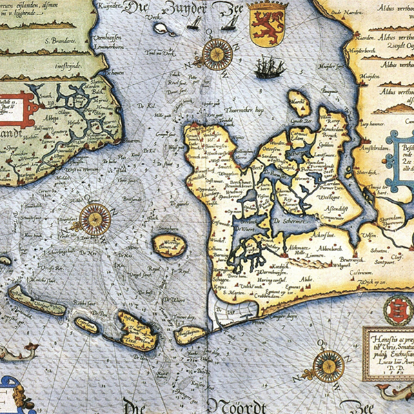
De kaart van Lucas Jansz. Waghenaer uit 1584 is de eerste in druk verschenen kaart van de Zuiderzee en van de vaargeulen met betonning in het westelijke deel van de Waddenzee. Deze kaart onderscheidt zich van de zeekaarten van dit gebied die nadien zijn verschenen, doordat ook de binnenwateren van Hollands Noorderkwartier worden getoond.1 De kaart geeft een zeldzaam beeld van de infrastructuur en het spreidingspatroon van de steden in het Noorderkwartier aan het eind van de zestiende eeuw. In de eeuwen daarna verandert het kaartbeeld ingrijpend door de landaanwinning, maar tot het midden van de negentiende eeuw blijft de scheepvaart het belangrijkste middel voor het vervoer van goederen en personen. De aanleg van de spoorwegen brengt daar verandering in.
Met de naam ‘Hollands Noorderkwartier’ wordt hier het hele gebied ten noorden van het Noordzeekanaal aangeduid, inclusief WestFriesland. In december 2011 werd in opdracht van de provincie Noord-Holland door de onderzoeksgroep ‘Randstad Holland in kaart’ een studie voltooid naar stationslocaties in dit gebied. De hoofdbestanddelen van het huidige spoorwegnet in het Noorderkwartier – de spoorlijnen en het merendeel van de stationslocaties – zijn al meer dan een eeuw oud.3 Deze schets van de topografische ontwikkeling van het Noorderkwartier maakt het spreidingspatroon van de steden inzichtelijk waarop het spoorwegnet werd geënt. Bovendien komt uit de grote hoeveelheid historische studies van dit gebied duidelijk naar voren hoe uitzonderlijk de verhouding is tussen geografische, sociaaleconomische en politiekbestuurlijke factoren, die de ontwikkeling van het Noorderkwartier heeft bepaald. In dit opzicht heeft het napluizen van deze omvangrijke literatuur inzichten opgeleverd die voor ons onderzoek naar de Randstad van belang zijn.
Citeerhulp
Gepubliceerd
Nummer
Sectie
Licentie
Copyright (c) 2013 Henk Engel

Dit werk wordt verdeeld onder een Naamsvermelding 4.0 Internationaal licentie.


